Saturday, December 8, 2012

St. John, US Virgin Islands


Anita and I took a break from Jersey and went to St. John in the US Virgin Islands.  It was a lot warmer, there was a lot less traffic, and there were a lot more bugs.  By the end of our stay, Anita was reminiscing about our bug-free Grand Canyon honeymoon.

Some of the photos turned out pretty well.  You can see them all at
https://picasaweb.google.com/remierice/201211xxStJohnSubset#
The grainy underwater shots were taken with a disposable film camera.  Next time I take underwater photos, I'll try a watertight case for my digital camera.

We stopped in Atlanta to see my bro and his fam over Thanksgiving.  My parents were there too.  The food was fantastic and Anita and I enjoyed seeing everyone.

We caught a flight to St. Thomas Island on Friday morning.  When we arrived, they were handing out small shots of rum at the airport.  Very tasty flavored stuff -- I had a mango shot.  As we would learn during our stay, rum is a byproduct of the sugar cane industry, which played a central role in the US Virgin Islands (and most other Caribbean islands too, I suspect...) history for the past several hundred years until the early 20th century.  Actually the islands were Danish until 1917.

There are two ferries from St. Thomas to St. John, our destination to the east of St. Thomas.  One, the Red Hook ferry, leaves from the east side of St. Thomas.  The other leaves from the main St. Thomas town, Charlotte Amelie.  We caught a taxi -- well, it was a Ford Econoline van, actually -- to the Red Hook ferry.  Our driver was crazy even for a taxi driver, and there are some wild up and downs.  He did play very relaxing music, though, which helped.  It was also a little disconcerting to be driving on the left side of the road.  Some very spoiled rich looking young tourists were egging the guy on to go faster which was pretty annoying.

We made it to St. John in one piece after an enjoyable ferry ride.  The caretaker at the place we rented met us and gave us a ride to the cottage.  We also rented his 2004 Suzuki Grand Vitara, which he picked us up in.  (It was not a swank ride, but got the job done.)  The island has a maximum speed limit of 20 mph, and the roads are somewhat harrowing.  It was good to see how he drove.  He was a very mellow guy who probably spends most of his time drinking margaritas and listening to Jimmy Buffett.  He and his wife were very nice to us.  The cottage was a nice little place, up a very steep rocky road not far from Coral Bay.  A 2wd truck could do it, but 4wd low range was nice.  It was a bit surprising to me that the cottage had no windows, just screens.  It is so warm on the island year-round that windows aren't necessary.  During a hurricane, I have no idea what they do.  They must board up the screens or something..?

We went out for dinner somewhere that night, and had some pretty good seafood.  In the morning, we sat out on the deck for breakfast.  It was the last morning we did that -- it's not that the bugs were that overwhelming at that moment, but the bites began to accumulate (esp. on Anita) and we had to try to minimize our exposure.  One could mostly escape the mosquitos, but sadly the noseeums weren't bothered by screens.  I probably should've advised Anita early on to go heavy on the DEET.  By the end of our stay, I was hosing her down with OFF Deep Woods, but it was too little too late.  Anyway, the view from the deck was pretty and we saw a few of the Bananaquits, which are ubiquitous on the island, and hummingbirds near a plantane tree that grew near the deck.  I never got a good photo of a bananaquit, but you can see the pretty bird here: http://farm7.staticflickr.com/6103/6890382204_1c4b154c6c_z.jpg.

In the cottage, btw, we found a little guidebook, Feet Fins and Four-Wheel Drive, that was an excellent supplement to the book I brought along, St. John Off the Beaten Path.  The little book is not available on Amazon, but seems to be self-published -- http://www.stjohnbeachguide.com/FFand4WD.htm.  It has some interesting and colorful stories in it.  For example, the author gives her best explanation of why people drive on the left in left-driver cars (i.e., the steering wheel is on the left just like in the US mainland).  She thinks it's because being on the left side of the car while driving on the left side of the road gave the driver the best vantage to try to avoid driving off of cliffs.

I had a great time, not being much bothered by the few bug bites that I got.  I think Anita had a good time despite her bitten-up condition which she withstood without crying about it more than once per day.  (Apparently my bro's wife was in the same condition on the Island, and attributes the bites to feminine products..?  Another factor is that men usually are a bit better covered up clothing-wise, and also have more hair, esp. leg hair, to fend them off.)

We got our snorkling rentals right away, and first snorkeled at Saltpond Bay which is well protected, and has has very pretty, shallow water.  Anita got the hang of it pretty fast, and we saw some cool fish immediately.  We snorkeled every day, and I think I snorkeled 2-3 times most days.  We also did several nice hikes and visited several ruins.  Here are some highlights:

Brown Bay
Our second morning, we headed out to Brown's Bay.  It was a short 1-mile hike to get there.  Lots of hermit crabs on this and every other path on St. John.  Though the beach sand itself wasn't that thrilling, the environment there (both above water and below) is spectacular.  We got settled down after the short hike in, and just sat watching the birds swoop around for a while.  Pelicans were hunting fish with a vengance.  (See photos.)  Dive, eat, fly, dive, eat, ...  Brown boobies were soaring around and occasionally diving.  The boobie is more graceful than the pelican, and I'm sad I didn't bring my camera to Brown's Bay where I could've gotten some awesome photos.  We saw pelicans many more times doing roughly the same thing, but this was the best boobie show (no pun intended) that I saw.  Also, there were flying fish dancing around in the water right in front of us.  In the bay, you snorkel through a shallow sea grassy environment in which hundreds and maybe thousands of conch (softball or larger sized sea snails, basically) inhabit the ~1 acre bay.  We also saw many starfish and a sting ray there.  The reef a little further out was very nice, but I didn't have my underwater camera yet, and have forgotten the exact details.


Here's my favorite pelican photo.  This guy's wing dips into the water just before he stabs at a fish.  Perhaps dipping the wingtip helps to "sling" him more quickly toward the water.  I also noted that they cock their heads back, and then ram it forward as they strike their target.  I never knew pelicans could be so athletic and aggressive.

Princess Bay
This bay has no beach because mangroves grow right into the water everywhere along the bank.  The web of mangrove roots act as a nursery for fish, many of which don't stay in the bays and reefs, but head out to the deeper sea.  I was stoked about this, and convinced Anita to snorkel out there.  The snorkeling is a little tough because you can't put your feet or you might accidentally put a toe on some pointy sea creature and hurt yourself.  Also, putting a foot down kicked up a large amount of debris that obscured the view.  Also, sneaking around in the mangrove roots was a little dark and spooky.  It wasn't for Anita.  So I snuck around alone for a while.  The roots were pretty, and there were a lot of fish.  It took some work and patience to see cool things though.  I think I was lucky to see a very big ugly fish.  I think it was a grouper growing to near full size before heading out to sea.

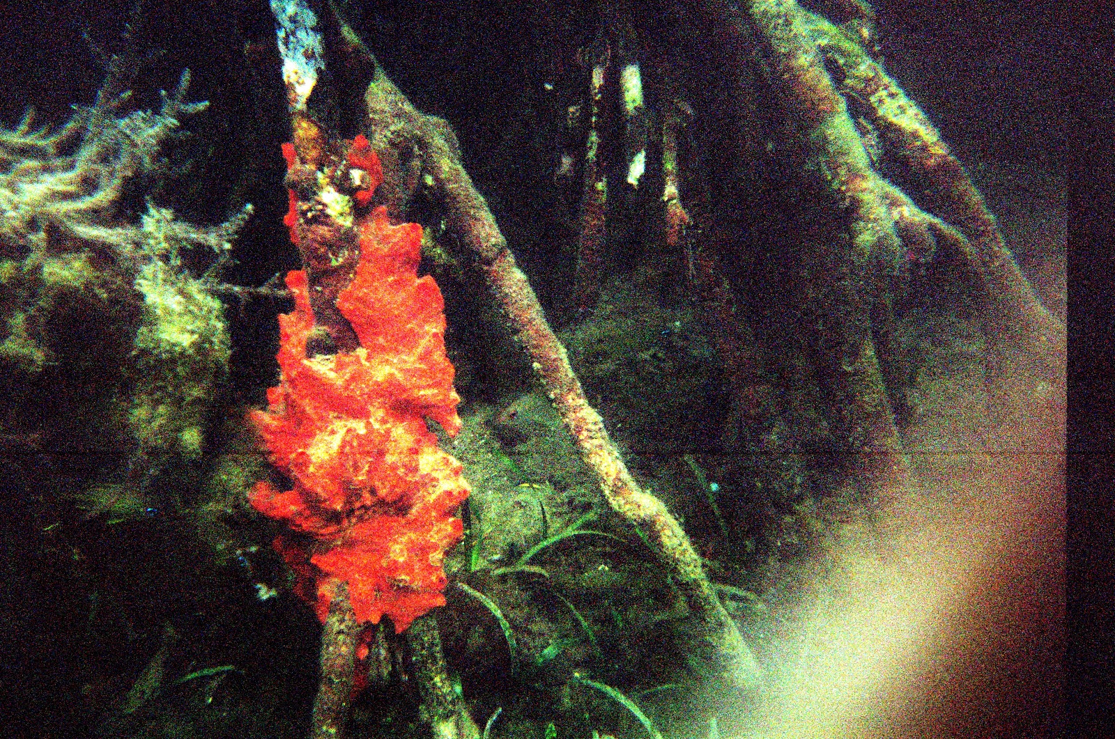
 Mangrove roots in Princess Bay.  Low light conditions prevented me from capturing any good fish photos, but this bright red coral shows up well.

Francis Bay
This place had the best beach.  It was very nice sand with trees growing near the edge so you could sit in the shade.  The crowd here was not as ridiculous as at some of the other "nice sand" beaches.  We got some good pelican shows and enjoyed sitting and reading a lot here.


Here I am at Francis Bay.  Idyllic scene. 

Oppenheimer Beach

J. Robert Oppenheimer lived on St. John after he was virtually crucified during the McCarthy era.  After running the Manhattan Project, and then leading the Institute for Advanced Study at Princeton, a bunch of flag-waving rednecks thanked him by putting him on trial and making his life hell for a while.  When I read that Oppie had lived on St. John, I thought it'd be a good time to read a biography about him.  So I got American Prometheus on my Kindle, and read a good chunk of it while on the island.  I'm very much enjoying his story so far, and the physics history in it is fascinating too. Turns out he liked to sail when he was younger, so must've enjoyed being on St. John with access to sailing all around the Caribbean.  Btw, he also loved horseback riding and spent a lot of summers at a little rough cabin at 10,000 ft in northern New Mexico (even before any physics was done at Los Alamos).  His cabin on St. John looks like shit at this point.  I guess he passed it down to his daughter, but she tragically committed suicide (maybe in the 80's), and left it to the St. John  community.  But the "community" has just let it go to rot more or less.  This fits with  the picture I saw of the island as a highly disorganized place.

Waterlemon Cay
A Cay is a small island formed on the surface of a coral reef.  Apparently an alternate spelling is "key" as in the Florida Keys.  This particular cay is within 100 yards of the nearby beach.  Anita and I snorkeled here on our last full day.  Probably the most spectacular snorkeling we did there.  Water could've been clearer, but there were lots of different fish, and a huge variety of coral.  I circumnavigated the cay, and on the way saw a trumpetfish, which I got a bad photo of, but which is a pretty bizarre and cool looking critter.


The ribbon-shaped thing in the photo center is a trumpetfish.

Here's a rainbow parrotfish.  These parrotfish chew up the coral and poop it out as sand.  I read that such fish produce most of the sand that makes the pretty beaches.  If you were very still and listened closely, you could hear the crunching of a parrotfish.

Annaberg Ruins
It was interesting to see these and other ruins, and learn something about the slavery-driven sugar cane operations on St. John and throughout the Caribbean.  One of the slaves that worked at this place ended up owning it after emancipation, and tried to continue operating it as a sugar mill.  He didn't have much luck, but he and his descendants lived here a long time among the ruins.  There is a well-preserved windmill tower and various other buildings, including slave quarters, a "dungeon" where slaves were punished, and various boiler rooms.  Making sugar requires a fairly sophisticated process of grinding (hence the need for the windmill), sifting, and boiling to just the right temperature.  Molasses is a byproduct (when the sugar doesn't come out right), and rum is made by fermenting the sugarcane scraps.

Anita at the Annaberg Ruins.  She's standing at the bread oven.  Behind her is the windmill structure.

Bordeaux Mountain and Reef Bay hikes
We did two long hikes.  It was nice to stretch the legs amidst all of the beaching and snorkeling.  Typical highs were about 80 degrees, so hiking conditions were pretty good, if a little too humid perhaps.  Bordeaux Mountain was a pretty simple up and down.  Either there is no trail to the actual top of the mountain, or nobody's gone to the trouble to make it clear how to find it.  So, the top of the hike is rather disappointing -- you end up on a road the the locals seem to largely treat as a garbage dump area.  The Reef Bay trail was more interesting.  The trail had markers that were probably put up in about 1975.  They are a bit hard to read, but are still better than nothing.  There are several ruins along the Reef Bay trail.  But a unique feature of the hike is the fresh water stream and pools.  Fresh water is very rare on the island, and the natives in 900 AD must've thought so too, because they put some petroglyphs here to mark the spot.


Petroglyphs made ca. 900 AD.  Some kind of monkey looking figures here. 

 This is an old steam engine that must've been used in the sugarcane operation at Reef Bay.

Miss Lucy's
This is a very cool "West Indian food" place right on the water in Coral Bay.  Friendly service, lot of local color -- like rasta dudes hanging out at the bar.  We got breakfast here one day, and dinner one night.  Mostly, we ate basic grocery store stuff at home, but it was fun to go out and spoil ourselves a bit.  The breakfast was delicious.  Anita got some kind of eggs benedict (Florentine benedict, whatever that is), and I got the pina colada pancakes.  These pancakes are awesome -- pinapple chunks and some kind of tasty sauce is cooked as a filling in the pancake.  The dinner was decadent.  I couldn't describe the dishes all that well, but there were scallops, some kind of sweet potato mash, and deep fried conch (kind of strange to be eating these little fried balls that reminded me strongly of the little guys I had just seen out in the water!)... Anita probably remembers much more.

In summary, this trip was an excellent getaway.  It was a lot of fun to see what the Caribbean island lifestyle is like.  We met a lot of nice people, enjoyed the warm weather and bathtub-temperature water, got a lot of R&R and reading done, saw lots of new and interesting wildlife, and soaked up some rays.

Saturday, September 29, 2012

1st Anniversary

On our 1st anniversary weekend, Anita and I took a trip to NYC. We hung in the city one day, and strolled through Central Park. There we saw an entertaining jazz band, a cool Egyptian obelisk (right by the Met) that I'd never seen before, and the cool “Cloud City” display on the Met upper deck. We stayed in a fancy Kimpton hotel on Park Place. Fancy in NYC means you have room to stretch your arms without hitting two walls. The next day, we swung by a busy breakfast place by Grand Central Station (at Pershing Place) and then headed out to the US Open tennis tournament. There, we saw Berdych pound out a victory over Almagro, then watched the up-and-coming Ryan Harrison (from Shreveport, LA, my birthplace) practicing with his 18-yr-old younger brother. The last match we saw was a mixed doubles match with a player called Leander Paes who's pushing 40, but who made it to the men's doubles final despite that fact. Maybe I can play pro tennis yet :) We briefly met with a guy I play tennis with (who happens to be our dentist) and some of his family/friends. One of the photos shows Anita with a cute little girl we met. She confided in me that she did not really like tennis, but she sure seemed to be having a ball :)  Altogether, quite a nice anniversary weekend.  All of my photos are on Picasa:
http://picasaweb.google.com/remierice/201209031stAnniversaryInNyc


See also Anita's blog post for some other details like or Italian dinner and better photos of the Open:
http://postcardsfromanita.blogspot.com/2012/09/somewhere-open.html

Until next time fair readers!  Perhaps I won't wait almost a year to make my next post.

Wednesday, December 28, 2011

Honeymoon Part II: Lake Powell, Zion, etc.

Where'd we leave off?  Let's see... We got to car at midday and headed to the Grand Canyon North Rim Lodge.  Went in hoping to find a room.  The front desk people were kinda short with Anita (plus they were unable to give us a room) and that set her outlook on the place from the beginning.  Turns out all the staff were pretty lax.  They were mostly youngsters hoping to have a good time, and didn't care much about guests.  The view was spectacular.  We watched the sunset and I had a couple of cold beers.  We stayed at the nearby campground that night and got up at the crack of day for the sunrise, which was pretty, but all the tourists kinda put a damper on it for me.  I prefer seeing it from Point Sublime with just me and my family/friends.

First sun striking Angel's Gate as viewed from the N. Rim G.C. visitor center.

We decided that hanging around the N Rim Lodge wasn't for us and that Anita was hiked out for the moment.  Heard about a California Condor release happening 100 miles to the NE in the Vermillion Cliffs, so headed there.  Was an interesting affair.  Learned about how the main cause of death of Condors is lead poisoning due to the lead fragments in the gut-piles left during deer hunts.  Even if the main part of the bullet is found, small pieces have gotten into the guts.  Condors eat that stuff and it apparently kills them or their young.  The people orchestrating the release were called the Perigrine Fund -- they used to be focused on Perigrine Falcons, but the Perigrines are in better shape now and so they switched to Condors.  Headed to Page, Arizona.  I thought Anita might be interested in seeing Glen Canyon Dam and we could do some swimming in Lake Powell.  The dam is an impressive, if somewhat abhorrent sight.

Glen Canyon dam.

Giant dams are feats of engineering something like the Egyptian pyramids.  But this one covered up some exquisitely beautiful canyon country with a very thick layer of sludge.  We went swimming near Lone Rock.  There, vehicles are allowed to drive willy nilly across the sandy beaches and in the surrounding hills.  Good ole boys have swarmed the area with their trucks.  I would've traded the AWD Kia Sedona for one of their trucks a couple of times as the thing bogged down in the deep sand. I was concerned that I might have to ask some drunk dude to help pull me out of the sand.  Swimming was nice especially since it was about 95 F outside.

Stayed that night with a Mormon couple who ran one of two B&B's in Page, AZ.  Well, we stayed with the couple (grandma and grandpa) and a large part of their family.  And the photos of the remainder of their family were plastered all over the B&B.  But what do you expect at a Mormon B&B?  In the morning over breakfast (and they did make some pretty mean pancakes), I kinda egged the very nice grandpa into telling me about his political views.  I was intrigued b/c he worked at the large local powerplant for 30 years.  One of his opinions is that Obama is a communist who is trying to control every aspect of our lives.  Also, God made the earth for humanity, so whatever we do is right.  Strangely, though, he is in favor of nuclear power instead of coal.  Go figure.  Blames environmentalists for stopping nuke power from taking hold in the US.  Dude also had some very strong opinions about gun rights.  Of course, he feels that Obama the communist is trying to strip him of all guns.  All Obama wants to do, as far as I know, is to prevent every good ole boy from having an AK-47.  Another insult the guy made to his own intelligence was that volcanoes pump out more CO2 than humanity does by burning fossil fuels.  He had a good buddy who was sure volcanoes put out more CO2, and this dude believed that his good buddy would never lead him astray.  I signed heir guest book and asked him to send me his reference about CO2 output.  Here's an article on this issue:
http://tamino.wordpress.com/2011/06/19/volcanic-co2/

All the breakfast banter provided good conversational material on the way to Zion Nat Park that morning.  We discussed gun rights.  Anita thinks guns should be banned in the US; I disagree -- my understanding is that the founding fathers felt that people should have guns so that they could overthrow the government if they had to.  This radical view came about from experience under British rule for so long, and the success they had overthrowing it with their guns.  Anita and I agree that Obama is probably not a communist :)  We got to Zion, hit the visitor center, and did a couple of short hikes.  While at the visitor center, I had the wildlife experience of the trip -- a little caterpillar!  He was crawling into the sidewalk danger zone.  He was two inches long and half an inch in diameter.  Beautiful markings.  I prodded him and he stood up on his back legs and sprouted some ugly, mean looking horns.  Awesome!  My mom identified the critter as the caterpillar of a western tiger swallowtail butterfly.  We went on to visit a hilltop food storage site of some ancient Anasazi.  Then did the Watchman hike.

Tiger swallowtail caterpillar.  Has "horns" that protrude when it gets riled up.

Next day, we hit the Zion Narrows.  We got to the part where you have to wade and Anita pulled up like a horse that spotted a snake.  She was spooked and though she did cross the first water, it was with the utmost reluctance.  I'm afraid I didn't give her enough time to settle in to the notion that the water crossing would not be dangerous before rushing her across.  This was what's known as a "dumb young husband move" and resulted in some emotional suffering.  I continued a bit further than she did, wading into nearly neck-deep 55 F water.  Intense.  Anyway, this hike was crawling with tourists and was paved until the last half-mile.  Of course, you could continue on another 5+ miles and escape the crowds.  We went back down-canyon and hiked the Emerald Pools trail.  The pools were a dirty brown in the fall conditions.  In the spring, I'm sure they're much more attractive.  We did spot a tarantula on this hike and a snake (non-venomous).

 
Anita and I on the trail near Emerald pools with Virgin riviera below.

On our final day in Zion, we hike to the Subway.  It's about an 8-mile round trip.  I figured it would take us about 4 hours.  Wrong.  Even the most gung-ho hikers would require 6 hrs.  We took a leisurely pace at first and took a wonderful break at a pool that had banks covered with cute little frogs.

 
A tiny frog near a pool on the Subway Hike.

Once we realized we were going to run out of daylight, we picked up the pace and finished in 8 hrs.  The huge upturned sandstone blocks covered with dino tracks are an impressive sight.


A dino track.  Amazing how this area was muddy, then suddenly changed such that this track was preserved.

 
These two large sandstone slabs are covered with dino tracks.

We tried to keep dry on the way up until the last mile or so when it is obvious that you gotta get wet.  On the way down you save some time by just sloshing down through the creek until the last mile which requires a climb out of the canyon.  At the top, we were treated to the beautiful Subway itself.  It's a highly unusual formation.  It's a bit like a slot canyon, but at the bottom of the slot, it opens into a wide tunnel -- like a subway!  The floor of the canyon at that point is immaculately carved by eons of gentle erosion so that there are deep blue pools here and foot-deep slots of rushing water there.  Amazing. 


The mouth of the Subway.

Looking down the Subway.  Anita took this photo which I think is suitable for Nat. Geographic.

Overall, it is a rough hike.  I whacked my head against trees and slipped cartoon-character-style into a completely horizontal position before plummeting to the wet, slimy, and very solid sandstone.  Anyway, we survived all the ups and downs of the hike and reached the car just before dark.  I ceremoniously leaned my trusty agave hiking stick, which I had plucked in the Grand Canyon, against the trail signpost for the next hiker to enjoy -- it was quite useful on this hike with all the water challenges.

On our last day, we hit the town in Vegas for a few hours before catching our plane back to MN.  We stopped into one of the casinos and found some penny slots that suited us perfectly.  I almost won $2 after starting from $1.  Then I got greedy and lost the entire wad.  Anita didn't fare any better.  But it was kinda fun.

Overall, I think it was a very successful honeymoon.  We could've had a good time in some
tropical or otherwise exotic place, but plane tickets would've cost a lot more, we probably
wouldn't have gotten nearly as much exercise.

Tuesday, November 22, 2011

Honeymoon Part I: North Rim of the Grand Canyon

Anita and I had a beautiful and excellent wedding in Minneapolis in September really deserves its own post (!), but I'm focusing on the outdoor stuff in this blog. After the wedding, we did a nice trip to eastern South Dakota (Badlands, Jewel Cave, Mt Rushmore, etc.) with Anita's family and Indian relatives. Then, we took a trip to CA, where I went to a workshop in the Bay area (Livermore), and then visited southern CA, where we saw friends and I visited a private fusion company. Finally, we were off on our honeymoon down in the Grand Canyon area. We did a 3-day backpacking tour from the North Rim on the Bill Hall trail to Thunder River, then toured down to "Lake" Powell (actually a reservoir that is highly controversial from an environmental standpoint). After visiting the Vermillion cliffs where we saw the launch of a few endangered California condors, we went down to Page, AZ, where we had an interesting stay in at a B&B with a Mormon family.  We concluded the trip by visiting Zion National Park.  For all the details, read on! For all photos, see:
https://picasaweb.google.com/remierice/20110920SfLaGcZionBestOf

This N Rim trip is probably my 4th or 5th trip to this part of the Canyon. My dad brought me and my Uncle Rick down here back in 1995. What an adventure we had with no GPS and limited backcountry experience :) Ended up eating fish from Thunder River for sustenance.. but that's another story. I figured with all my accumulated mountaineering and backcountry travel experience, I'd have no trouble guiding my (physically quite capable, but not exactly mountain-tough) new bride down here without ending our marriage and hopefully making it stronger by sharing this beautiful place together :)

We flew into Las Vegas on Tues the 20th of Sept, and headed to Pipe Springs National Monument ranger station to get a permit. We were too late, so skipped the permit (which actually turned out to be legal after all). We headed down into the Kaibab (the forest on the North Rim of the GC) to camp that night. Found really nice spot near turnoff onto the little FS425 that leads out to some excellent N Rim hiking. Saw a bushy-white-tailed Kaibab squirrel (famous for its existence as a distinct species after separation from its South Rim cousin squirrel) and a few deer, but no turkey or anything else. Wednesday morning, we headed to the Bill Hall trail parking lot at Monument Point.

Looking down from Monument Point. Bridger's Knoll center left. The esplanade is the flatish area upon which the Knoll sits. Powell Plateau is the flat feature in the distance at left.

As we started the hike, we saw a Perigrine cruising around but it didn't swoop down past us. Didn't see a whole lot of other wildlife for the duration of the GC hike, but the breathtaking vistas alone are sufficient to hold one's interest. No rattlesnakes (but didn't go beating through the bushes). Anita was somewhat distressed about the exposure in some spots as we headed down the trail, dropping through about 1000 feet and many millions of years of rock layers. Notably, near the beginning of the hike, there are some hair-raising dropoffs as you walk along the trail. In one or two spots, the trail has mostly sluffed off, and you have to take a big step over the sluffed spot. Then the little step down the Toroweap went smooth, but was still a little scary for her.

Anita questioning her new husband's honeymoon location choice (hey, it was a JOINT decision!).

After about 1000 feet, you hit the so-called esplanade, a layer of tough sandstone called Supai, which forms a sidewalk-like surface that rings the canyon. There is an interesting geological story behind the Esplanade: above the Supai is a layer called the Hermit Shale. The Colorado easily cut through this shale layer (after slicing more slowly through the Toroweap and Coconino above). Then it dwelled for a long time in the Shale layer, slowly washing it downstream. As it washed some away, it left overhanging cliffs of Toroweap and Coconino. These cliffs, once deeply undercut, broke away and their crumbled remains were also washed downstream. The river meandered in the Shale, carving away at the cliffs until the Supai "sidewalk" of the Grand Canyon was exposed. You can see the esplanade best in the first photo from Monument Point.

We camped on the Esplanade at roughly the planned spot, just above Surprise Valley. Some people were occupying the best little spots under the ledges, but a few hundred meters further (and right near the rim), there was a nice spot. Brought 6 L each down from Monument Point. Turns out we needed 4 L each. Left 2 L at bottom of first decent from Mon Point. Left 2 L or at first camp. The camp was within 100 feet of the rim of Surprise Valley, which has to be one of the more astounding geologic features of the Grand Canyon (see photo). Surprise Valley was spread below us to the south, and to the east was Powell Plateau, a vast and strikingly flat feature which has one of the few virgin Ponderosa Pine forests in the world.

Standing near our first campsite on the esplanade .

What a view just 100 feet from our camp. Surprise Valley was created in a colossal landslide. Water had greased the skids, and the Supai and Redwall collapsed in a rotational landslide, forming the valley and blocking the Colorado river.

Headed down to Thunder Spring Thursday morn. Still some distress on Anita's part hiking trail leading down to Surprise Valley. More distress on the way to the Spring itself. Again some hairy spots. To me, these hairy spots go completely unnoticed unless i'm hiking with somebody like Anita who's scared of heights. I came to recognize when she'd be scared. On the final trail down, we saw a dude hiking up that we thought might've been a ranger. He was a young guy (my age), with the posture of a fresh military recruit out to impress, and a clean-shaven face.  He had a big and very clean stiff-brimmed hat. As we later learned, he wasn't a ranger after all. When we got to the Spring, Anita was ready to sit for a while. There was a woman sitting there who we briefly chatted with. She was sitting reading a book and explained that her badass hubby had busted it over toward Deer Creek that morning and was coming back later in the evening. I didn't guess it at the time, but this was the wife of "the ranger".

 On some rocks while hiking down into Surprise Valley.

From the Spring, I scouted ahead to look at the trail. It was too tough for her, and I couldn't justify asking her to come down to the upper camp. We didn't have permit anyway, although it appeared that there would be a nice two-person spot remaining for the night. (Two other groups were going to be taking up the main sites.) Plenty of rafters down near Thunder Spring. We had several offers to join rafters for dinner down at the CO river at their camps. They, as usual, were loaded for bear, foodwise. Swordfish was apparently on the menu.

Lots of rafters were climbing around near the spring pouroff

Headed back up to Surprise Valley and camped there that night. Wandered along trail to near the Y intersection and found nice spot a few hundred yards short of that. Our food was really good. We did simple things like Idahoan mashed potatoes with jerkey + dried fruit, and tortilini pasta. We got some non-meat jerkey called Seitan (http://en.wikipedia.org/wiki/Wheat_gluten_%28food%29).

Friday morning, we got cracking at 4 am and hiking by 5. We made the Esplanade a little before 8 and stopped for a good brunch of pita bread, butter, peanut butter, oatmeal, string cheese, etc. "The ranger" and his wife had camped up in Surprise Valley right near the dropoff to Thunder Spring. They reached the Esplanade and passed us just as we were getting going again. We leapfrogged them several times on our way up to Monument Point.  The ranger and his wife were all business on the trail.  The only conversation we had was when we talked about what a bunch of slobs people are on the trail.  Yes, people are a little ridiculous to ditch all the stuff they do.  Food, water bottles, etc.  But I must admit that on one trip somebody (it MIGHT have been my own father) decided to ditch all sorts of junk out of desperation -- we were really low on water and out of food! -- including an entire backpack and a thermarest.

Hardly any flowers were out in the fall, but there were some impressive agave stalks out on the esplanade.  This is a good example of the "sidewalk" nature of the esplanade.

 The fruit at the end of an agave stalk.

The walking was pretty smooth and easy along the esplanade. Not too hot mid morning. Made good time to the forty-something switchbacks leading up to Monument Point. The guidebook I have claimed there are exactly 49 switchbacks, so I decided to count. To keep myself and Anita entertained, I decided to tell the story of my life, one year at a time as we hiked up beginning on switchback 15 at age 15. The pace was slow and plodding in the mid-day heat, so I had plenty of time to think as I breathed deeply and sweated my way up. When I got to 31, I started telling the story of Anita and Eric. At age 35, we had a child. At age 37, we had another. At age 45, the first kid (named Liam as an abbreviation of William) was 10. Etc. It was kinda fun. Eric became a professional tennis coach, for example. The final push to the top was hot and slow, but no big problems. Both of us had no major foot pain, and we had plenty of water.

The honeymoon so far wasn't as relaxing as laying in the sun on a tropical beach. However, it was an experience that few can say they've had.

Thursday, April 7, 2011

Elfin Lakes tour

Elfin Lakes ski tour
Eric Meier and Jeff Schomaker
Friday-Saturday April 1-2, 2011

You're a grad student being hammered by research work.. sitting around day after day running simulations and writing papers. You're in Seattle near the end of the winter.. it's been raining something fierce and moss is growing between your toes. What do you do? You get your ass out into the mountains for a ski tour! I tell you, it's like a religious experience for me to get way up in the mountains, preferably in the sun with an expansive view of wild and ragged mountain peaks. This trip was no exception. Awesome. Everything comes into focus out there.

Some noteworthy things have happened since I last blogged (like getting engaged!), but I haven't gotten out on many good adventures this winter. In November, just before they shut down Hwy 20 over the Cascades, Reid, Jeff, and I did a nice skiing day trip up by Blue Lake. Also, the three of us did a day trip at Baker in January. Finally, I got out again! Jeff and I headed up to Canada. Jeff was none too optimistic that the weather or skiing would be any good. But it all turned out pretty well.

All pics (and a video somewhere near the end of the picture set) can be found at
https://picasaweb.google.com/remierice/20110401ElfinLakesWJeff#

We headed up across the Canadian border to Garibaldi Provincial Park on Friday. As usual when one of the infamous Meier brothers crosses into Canada, they want to do a full cavity search. Well, it's not that bad, but they always stop me going in for a few minutes. It's kinda hilarious how the Canadians have a need to waste their own time and mine. I joked with Jeff, who was driving, that they always stop me on the way into the US too.. but they give the driver the cavity search. (Actually, we did get stopped coming back into the US! They harassed us for 1/2 hr or so. Jeff was sweating bullets because he had some prescription pain killers for emergencies. They let him off the hook, telling him he should not cross with painkillers.. but if he was going to, he should crank up his operation some.)

We stayed in an awesome shelter in Garibaldi Park near Elfin Lakes. The shelter comes equipped with a heavy duty propane heater, a kitchen with four propane stoves and lots of pots. It's user maintained and is in good shape. Lots of propane.

Elfin Lakes Shelter upon arrival Friday eve.


On Friday night, the shelter was pretty quiet. Only three chicks from Vancouver were there. They were pretty cool and didn't smell too bad, which was good. One of them was a nerd like me and wanted to play some chess. I took her up and we had a good game. Two of them spoke French (one was a teacher of French), so I spoke some with them. She said she thought Americans like the French (so maybe that's why I would pick up the language). Au contraire, I told her. Most Americans are French-hating rednecks.

We slept like lazy bums until 7:00. When we woke up, things looked marginal. But after about 1/2 hour, it looked absolutely gorgeous and we seized the day. Good visibility was needed to navigate the terrain around there without being in danger of avalanche, cornice failure, etc.


Elfin Lakes shelter with Garibaldi in background


Elfin Lakes area panorama

After some vigorous exercise, we made it to the top of Diamond Head which is about 7,000 ft high at the shoulder of the larger Garibaldi. Looking around at the top was quite a treat.

Panorama from the top of Diamond Head. Garibaldi at right. Coast Range in distance.

Had some great turns on the way down... until I sprained my ankle during the last downhill run. It was a pretty bad sprain and made it quite painful to struggle down seven miles to the car. It's five days after the injury, and the swelling is basically gone, but it's still tough to go down stairs or to move aggressively at all. Anyway, it's a small price to pay for the pleasure of the trip.

On the way down (limping along), we ran into a weird dude from Vancouver who wasn't using his skis. They had good skins on them and he had good boots, but he was carrying them. He asked us, "why does anybody use these things on the way up.. I do better walking." We said "Uhhh. You new to this? You might want to try skinning again." Skinning is a great way to get around in the mountains.

Wednesday, October 20, 2010

Forbidden Peak

Forbidden Peak West Ridge
Reid McCaul and Eric Meier
Oct. 16-17, 2010

Reid and I thought about doing something a little more aggressive than this. I’m glad we didn’t. This was quite sufficient. I didn’t know it until Reid pointed it out, but this route, (Forbidden Peak, West Ridge), is one of the fifty climbs made famous in the popular book, Fifty Classic Climbs in North America (http://en.wikipedia.org/wiki/Fifty_Classic_Climbs_of_North_America), by Roper and Steck. I’ve climbed one other route on their list – Mount Rainer's Liberty Ridge.

Mt Forbidden photo by John Roper, July 27, 1968. The west ridge is the one pointing toward the upper left. The glacier extends at least 1000 feet into Boston Basin (to the left of the peak in this photo). Now, it spans just a couple hundred feet of altitude.

We got on the road from Seattle Saturday morning at about 7:30. Made a grocery stop and picked up some food including a bag of fabulous trail mix which was soon to be eaten by mice. Checked in at the ranger station in Marblemount at 9:30 and got to the TH (about 3,500 feet elevation) at around 10:30. Route from the road up past the old diamond mine and to the Boston Basin high camp was fairly straightforward except where the trail was washed out in a few places near the low camp. Temperatures in the shade were near freezing, and ice presented a challenge at some stream crossings. Snow was sticking in spots as we reached 5,000 ft. Got to high camp at 6,400 feet at about 3:30. Had some time to kill and did a 2-hour side trip over to a saddle just below Mount Torment (all the peaks around here seemed to have great names). From the saddle, had a great view of Eldorado Peak. From anywhere in Boston Basin, the view of Johannesburg Mountain is striking. I got some great pics of all this scenery including sunset. Unfortunately, my camera did not finish the trip with me. After some discussion of the sub-relativistic Doppler shifting of light, we were tuckered out and hit the rack.

We woke at 5:30 and got going by 7 Sunday morning. We had noticed a few mice the previous night, and I put my trail mix into my drawstring canvas bag and into my pack. This was not adequate protection from these driven little bastards. They had eaten almost all of it by morning. They brazenly snuck in to grab the last morsels even as I was chasing them around camp with intent to kill.

Beckey’s guidebook description said it would take 6 hrs to the summit, then 4 hrs back down to high camp. That would make it 5 pm. Barely enough time to make it out before darkness which fell at 7 to 7:30 pm. Beckey is not known for the high accuracy of his time estimates (or for his exact route descriptions), so we expected our headlights might come in handy. On the approach hike, we quickly warmed up and took off our down jackets. I took my camera off and set it down. I never picked it up again. I realized 15 minutes later that I’d left it. I figured I could probably find it on the way down. No such luck. The terrain around there is too monotonous, not to mention that it was getting dark and we were in a hurry. The marmots are having a good time with it, I’m sure. The final approach to the technical section involves crossing tiny little glacier that has almost melted away (thanks global warming!). We decided it was beneath us to put our crampons on. This proved to be a minor mistake. Reid got off the glacier and onto a nearby rock outcrop sooner than I did. I went a little higher where it’s a little steeper and a little icier… where my mountaineering boots could barely penetrate the ice to give me any grip. This made for some fun ice climbing on a 45 degree slope with only my mountaineering axe. But I made it after five or ten minutes of quad burning workout. I think this part of the approach was the beginning of the end for my quads which are still sore now, 3 days post climb. After getting onto the rock, things scarcely improved during the mixed rock and ice, tooth and nail up to a safe spot. Greater respect for this tricky approach would be appropriate.

It was a great relief to put on climbing shoes and rope up. The usual couloir was out of shape, so we took the alternate route recommended by Beckey. Ascent is straightforward to the notch in the west ridge. We simulclimbed a good chunk before reaching some difficult sections. One of the first moves is a long step over a spectacular abyss. My oh my, it is exciting. The route favors the north side of the ridge. Unfortunately, that’s where the snow collects first. But there was never more than a couple of inches on the important holds, so it only added a point or two to the climb’s class 5.4(ish) rating. Mostly, it was easy class 4 scrambling albeit with dizzying drops on either side. After getting off to a rocky (icy?) start on the glacier, I was happy to have Reid (a far more experienced climber than me anyway) in the lead.

Near the summit, Mount Baker peeked out from behind Eldorado which had been neatly hiding it. On top at 1 pm, exactly 6 hours after departing camp, the summit views were magnificent. Reid took a few photos with his iPhone.

Me on top of Forbidden. Eldorado is seen with Baker peeking from behind it.


Here’s the view of Johannesburg from the top.


Reid with Mt Logan in background. Heavily crevassed Fremont Glacier is below Logan.

Our downclimb took us 5.5 hours. Maybe we can blame the snow for the slow pace. Spent half an hour looking for my poor camera to no avail. Raced down the mountain in the near dark. Managed to stay on the trail almost exclusively which was no mean feat. This rapid descent took a toll on the quads, knees and feet. As Reid says, “the dogs were barking”, meaning our feet were hammered. We had quite a philosophical discussion about how some people can manage to enjoy climbing despite the significant pain that must be endured.

Reached the car just before 9 pm. I knew Anita would be getting concerned, so I was anxious to get down into cell phone range. (Reid had told his gf that she should not worry until midday Monday unless the area is hit by a nuke.) On the way down the dirt road, we were hailed by a woman in an SUV. She was distressed and asked us if we knew much about the route up Eldorado. Why? Her husband was due to be down that evening and he hadn’t called yet. Reid (who has done Eldorado) tried to explain that the routefinding is tough and they may be spending the night up there. Impressive that she drove two hours from Bellingham. Clearly her hubby is a fairly new climber or she would be used to this shit by now. Hopefully he made it down safely.

All in all, a fabulous climb. Great to be up there on this classic route without seeing any another climbers. Great weather. Snow will probably make the route impossible later this week.

Tuesday, August 31, 2010

Dark Side of the Moon

That title sounds cool, but should be amended to read "Far Side of the Moon". The moon rotates around the earth and is "locked" so that we only see one face of it. My sister and bro-in-law were wondering what the explanation was for this. I took a crack at it, and had a tough time convincing them. So, I've studied up and am writing it here for them.

Why is the moon locked facing the earth? I looked this up years ago and learned that it is basically due to what's called "tidal locking". From the wikipedia article on tidal locking, "A tidally locked body takes just as long to rotate around its own axis as it does to revolve around its partner." Tides basically cause an spherical body (like the moon and earth) to be stretched in the direction of it's orbital partner.

How is it that something related to tides could cause a celestial dance between giant objects like the earth and moon? Don't tides just make the oceans go up and down? The image below gives some idea of what's happening on earth.


Tidal bulges. Earth's oceans are stretched toward the moon on the side facing the moon and away from the moon on the opposite side. The diagram above also shows earth's rotation dragging the stretched shape slightly counterclockwise such that the bulge "leads" the moon.

The moon is also stretched like the earth, and the stretched direction always points to the earth. This is because when the stretched direction is not pointed at the earth, there is a correcting force that rotates the stretched direction to point at earth.

When the moon was liquid, it was bulged, and rotated "under the bulge" just like the earth does. As it cooled and froze, it's rotational energy must've tried to move the bulge from its orientation toward earth, but the corrective force mentioned won and we have our tidally locked moon.

Cool, huh? My dad asked the tough question of why the stretched shape is formed. For example, why doesn't earth just have a single bulge on the side facing the moon? Why another bulge on the opposite side? How the devil does this really work? Ike Newton was one of the first (if not the first) to understand this scientifically. The wikipedia page on tidal force is excellent. A summary follows.

Tidal forces diagram. Moon's gravitational forces (red arrows) are acting on the earth (the black sphere).

The red arrows in the top pane shows the moon's gravity which is weaker farther from the moon. The earth (the black sphere) is in free fall. Thus, it makes sense to subtract off the average gravitational force acting on the earth. This is done in the lower pane. Now you can see the forces that cause the tidal stretching.

Keep in mind that the tides are only ~10 feet. This is a tiny bulge for an object with a radius of 20 million feet.

Another cool thing I learned in the article is that the debris that makes up Saturn's rings would have condensed into moons if not for tidal forces exerted by Saturn.


Cassini image of Saturn.

Tidal forces are stronger closer to the source of gravity. Moons formed around Saturn when the debris was far enough away that tidal forces didn't disturb the formation.