Reid McCaul and Eric Meier
Oct. 16-17, 2010
Reid and I thought about doing something a little more aggressive than this. I’m glad we didn’t. This was quite sufficient. I didn’t know it until Reid pointed it out, but this route, (Forbidden Peak, West Ridge), is one of the fifty climbs made famous in the popular book, Fifty Classic Climbs in North America (http://en.wikipedia.org/wiki/Fifty_Classic_Climbs_of_North_America), by Roper and Steck. I’ve climbed one other route on their list – Mount Rainer's Liberty Ridge.

Mt Forbidden photo by John Roper, July 27, 1968. The west ridge is the one pointing toward the upper left. The glacier extends at least 1000 feet into Boston Basin (to the left of the peak in this photo). Now, it spans just a couple hundred feet of altitude.
We got on the road from Seattle Saturday morning at about 7:30. Made a grocery stop and picked up some food including a bag of fabulous trail mix which was soon to be eaten by mice. Checked in at the ranger station in Marblemount at 9:30 and got to the TH (about 3,500 feet elevation) at around 10:30. Route from the road up past the old diamond mine and to the Boston Basin high camp was fairly straightforward except where the trail was washed out in a few places near the low camp. Temperatures in the shade were near freezing, and ice presented a challenge at some stream crossings. Snow was sticking in spots as we reached 5,000 ft. Got to high camp at 6,400 feet at about 3:30. Had some time to kill and did a 2-hour side trip over to a saddle just below Mount Torment (all the peaks around here seemed to have great names). From the saddle, had a great view of Eldorado Peak. From anywhere in Boston Basin, the view of Johannesburg Mountain is striking. I got some great pics of all this scenery including sunset. Unfortunately, my camera did not finish the trip with me. After some discussion of the sub-relativistic Doppler shifting of light, we were tuckered out and hit the rack.
We woke at 5:30 and got going by 7 Sunday morning. We had noticed a few mice the previous night, and I put my trail mix into my drawstring canvas bag and into my pack. This was not adequate protection from these driven little bastards. They had eaten almost all of it by morning. They brazenly snuck in to grab the last morsels even as I was chasing them around camp with intent to kill.
Beckey’s guidebook description said it would take 6 hrs to the summit, then 4 hrs back down to high camp. That would make it 5 pm. Barely enough time to make it out before darkness which fell at 7 to 7:30 pm. Beckey is not known for the high accuracy of his time estimates (or for his exact route descriptions), so we expected our headlights might come in handy. On the approach hike, we quickly warmed up and took off our down jackets. I took my camera off and set it down. I never picked it up again. I realized 15 minutes later that I’d left it. I figured I could probably find it on the way down. No such luck. The terrain around there is too monotonous, not to mention that it was getting dark and we were in a hurry. The marmots are having a good time with it, I’m sure. The final approach to the technical section involves crossing tiny little glacier that has almost melted away (thanks global warming!). We decided it was beneath us to put our crampons on. This proved to be a minor mistake. Reid got off the glacier and onto a nearby rock outcrop sooner than I did. I went a little higher where it’s a little steeper and a little icier… where my mountaineering boots could barely penetrate the ice to give me any grip. This made for some fun ice climbing on a 45 degree slope with only my mountaineering axe. But I made it after five or ten minutes of quad burning workout. I think this part of the approach was the beginning of the end for my quads which are still sore now, 3 days post climb. After getting onto the rock, things scarcely improved during the mixed rock and ice, tooth and nail up to a safe spot. Greater respect for this tricky approach would be appropriate.
It was a great relief to put on climbing shoes and rope up. The usual couloir was out of shape, so we took the alternate route recommended by Beckey. Ascent is straightforward to the notch in the west ridge. We simulclimbed a good chunk before reaching some difficult sections. One of the first moves is a long step over a spectacular abyss. My oh my, it is exciting. The route favors the north side of the ridge. Unfortunately, that’s where the snow collects first. But there was never more than a couple of inches on the important holds, so it only added a point or two to the climb’s class 5.4(ish) rating. Mostly, it was easy class 4 scrambling albeit with dizzying drops on either side. After getting off to a rocky (icy?) start on the glacier, I was happy to have Reid (a far more experienced climber than me anyway) in the lead.
Near the summit, Mount Baker peeked out from behind Eldorado which had been neatly hiding it. On top at 1 pm, exactly 6 hours after departing camp, the summit views were magnificent. Reid took a few photos with his iPhone.
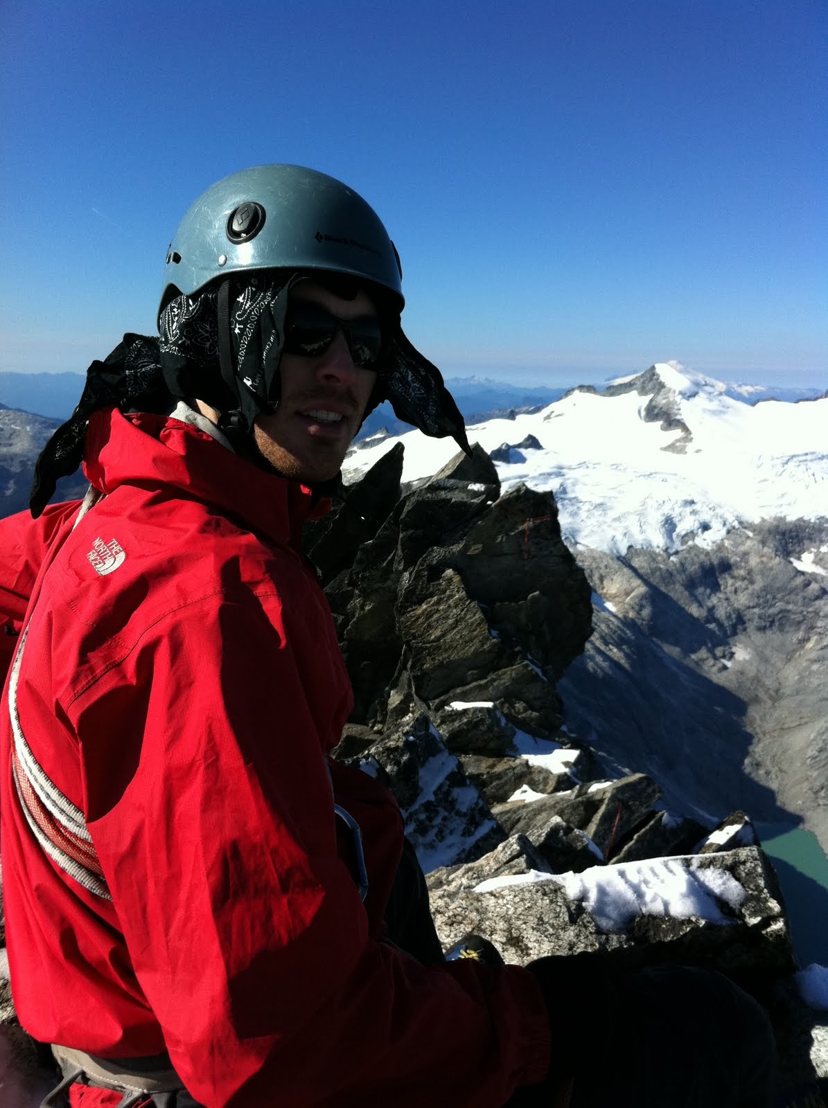
Me on top of Forbidden. Eldorado is seen with Baker peeking from behind it.

Here’s the view of Johannesburg from the top.

Reid with Mt Logan in background. Heavily crevassed Fremont Glacier is below Logan.
Our downclimb took us 5.5 hours. Maybe we can blame the snow for the slow pace. Spent half an hour looking for my poor camera to no avail. Raced down the mountain in the near dark. Managed to stay on the trail almost exclusively which was no mean feat. This rapid descent took a toll on the quads, knees and feet. As Reid says, “the dogs were barking”, meaning our feet were hammered. We had quite a philosophical discussion about how some people can manage to enjoy climbing despite the significant pain that must be endured.
Reached the car just before 9 pm. I knew Anita would be getting concerned, so I was anxious to get down into cell phone range. (Reid had told his gf that she should not worry until midday Monday unless the area is hit by a nuke.) On the way down the dirt road, we were hailed by a woman in an SUV. She was distressed and asked us if we knew much about the route up Eldorado. Why? Her husband was due to be down that evening and he hadn’t called yet. Reid (who has done Eldorado) tried to explain that the routefinding is tough and they may be spending the night up there. Impressive that she drove two hours from Bellingham. Clearly her hubby is a fairly new climber or she would be used to this shit by now. Hopefully he made it down safely.
All in all, a fabulous climb. Great to be up there on this classic route without seeing any another climbers. Great weather. Snow will probably make the route impossible later this week.


4 comments:
Your description gives me chills, Eric. This was fun??! It was interesting reading, but scary.
The mountain's name is appropriate - you should have paid attention to it, maybe.
Too bad about the camera. Not your SLR, I hope? The mice surely appreciated you and your trail mix stopping by.
I like the way you wrote this up, with funny parts. I think I'm going to start saying "the dogs are barking" that's a good one.
I was wondering too if it was your slr. Mama's camera is really a nice one, not crazy expensive you should ask her about it if you're in the market now for a new one.
No, it was the cheap camera. Yes, I'm in the market for a new one now..
now u know that "hiding" food in perfectly good backpacks and bags only leads to holes.
hanging usually works but a pie tin with a hole for the cord created some amusement to george steck in the grand canyon once watching them climb down the cord and slide off the tin pan when trying to climb over the edge.
somehow on our GC trips our camp sites must have been too remote to have trained the mice.
steve
Post a Comment